Mont-Blanc – France, Europe (Info and Pictures)
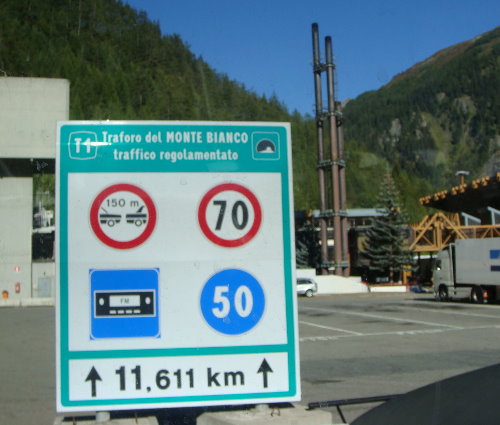
Ranked 11th in the world, Mont Blanc (or Monte Bianco in Italian) is the highest peak in Western Europe at over 15780 ft. or 4810m. The mountain lies between Haute-Savoie Departement in France and the Aosta Valley region in Italy. The notable towns near Mont Blanc in these two regions are Chamonix in France and Courmayeur in Italy. Both countries claim the peak as lying within their boundaries. The Mont Blanc tunnel (completed in 1965) connecting the two countries of France and Italy, runs under the mountain. It is 7 and a quarter mile long (or 11.6 km).

The road tunnel under Mont-Blanc is 11.61 Km long.
The Mont Blanc massif is a very popular tourist spot and also one of the best areas in the world for snow sports, mountaineering and hiking. The first winter Olympics was held in Chamonix. Mont Blanc was first climbed/ascended by Jacques Balmat and Dr. Michel Paccard on 8th August 1786. However today numerous tourists mountaineers visit and ascend the mountain. It is estimated that annually over 20000 people come to ascend the mount. Amongst experienced mountaineers it is considered fairly easy ascent but it is a long ascent and poses the danger of rock slides (apart from the high altitude – naturally!)
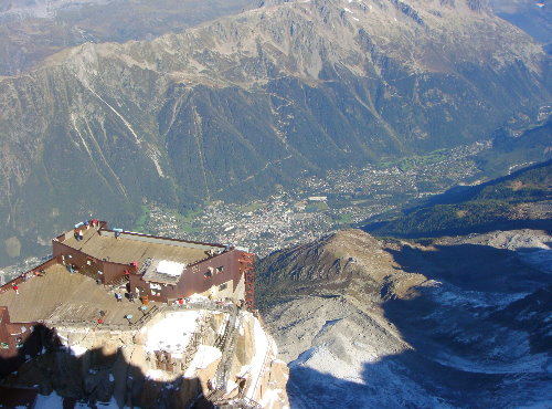
The most popular viewing area for tourists is the Auiguille du Midi. It can be reached by taking the cable car from Chamonix.
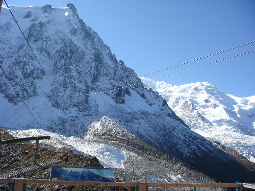
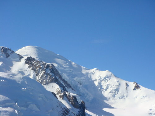
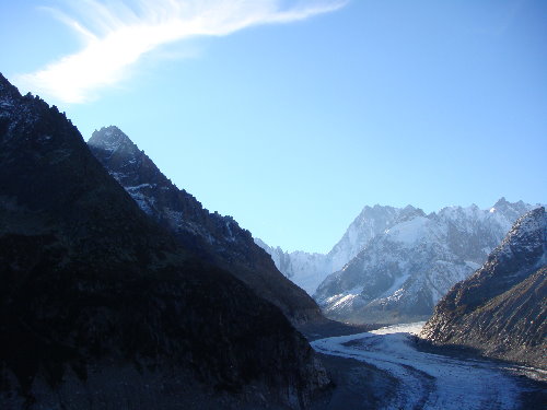
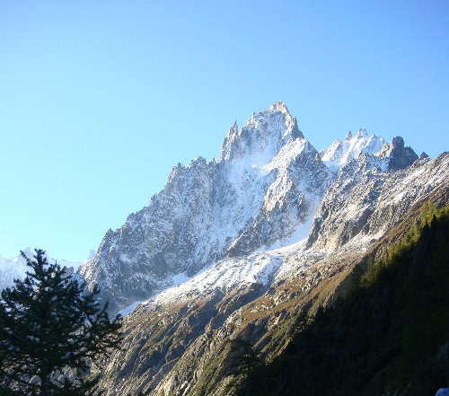
The views of the Mont-Blanc range and adjoining areas are breathtaking.
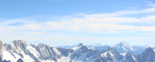
Its pristine and incredible.
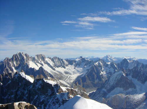
We were told that up until few years back these were also covered with snow. But now its almost barren. Global warming? Maybe!
Some Classic climbing routes on Mont Blanc include –
• The Voie Royale (a.k.a the Voie de Cristalliers). One can start the ascent from Nid d’Aigle towards Tete Rousse cabin, through Gouter Corridor to Gouter Cabin shelter for the night. The second day the route leads to the Dome du Gouter, Vallot cabin to L’Arrete des Bosses. One can take the TMB (Tramway du Mont-Blanc) to Nid d’Aigle from Saint-Gervais-les-Bains.
• La route des Aiguilles Grises also known as the Normal Italian Itinerary. One gets to traverse the Miage glacier. Night is spent at Gonella cabin. Next day the route takes you through Col des Aiguilles Grises, the Dome du Gouter, ending at L’Arrete des Bosses.
• La Voie des 3 Monts (La Traversee). This route starts from Col du Midi. One can take the Teleferique de l’Aiguille du Midi from Chamonix to reach here. The night is spent at Cosmiques cabin. The next day Mont Blanc du Tacul and Mont Maudit are covered.
• Miage-Bionnassay-Mont Blanc crossing. Starts from Contamines-Montjoie and ends at the Dome du Gouter. This is a three day ascend. First night is at Conscrits cabin and the second night at Durier cabin.
Mont Blanc Peak in France
Among the mountains in the Alps, the Mont Blanc is the highest. It rises to a height of 4,807.81 meters above sea level. This makes it the second highest mountain in Europe and the eleventh highest mountain in the world.
Gouter Route
Usually considered the easiest and most popular route to Mont Blanc, the Gouter Route climbs to 4,808 metres. The most challenging section is the Grand Couloir, where rockfall is a common hazard. Aside from rockfall, other dangers include serac falls and avalanches. During the winter months, climbers must be aware of the risks.
While the route is relatively easy, a good level of physical fitness and technical skills are required. In addition, the mountain is notorious for unstable weather conditions, which can change rapidly. Also, mountaineers must be aware of the risks associated with crevasses.
The Gouter route is not a difficult route, but a high level of physical fitness and experience with crampons is recommended. Climbers should check the weather before setting out. It is also recommended to carry metal bars for aid in the more technical sections.
The route passes by Gouter Hut and the Refuge de Tete Rousse, which are both located at the base of the Aig. These huts are very popular and must be booked well in advance.
La route des Aiguilles Grises
Located on the French-Italian border, Mont Blanc is the highest mountain in non-far east Europe. Its majestic ridges have inspired generations of alpinists. The mountain chain is also a popular tourist destination. Many routes on the mountain offer a variety of difficulties.
One of the most popular routes on the French side is the Three Mont Blancs. This route crosses the Mont Blanc du Tacul and the Aiguille du Midi. The route is long, with a total elevation gain of over 1700 meters. The climb requires a high level of fitness and experience.
The Italian side of Mont Blanc is also home to several routes. These include the Pope Route, which is an easy and relatively safe way to ascend or descend the mountain.
The Grands Mulets is another route that is popular. The hut is located at the cable car station in Plan de l’Aiguille. The route takes climbers up to the Refuge de Tete Rousse. The hut is situated at 3167m.
Portes du Soleil
Whether you’re looking to ride a lift, take a hike, go ice diving, or just ski, Portes du Soleil is the perfect winter sport destination. It’s located on the border of France and Switzerland, and spans 600 kilometers of skiing.
Portes du Soleil is a vast ski region that covers twelve resort villages in Switzerland and France. There are five Swiss resorts and seven French resorts. Portes du Soleil is also the second largest ski region in the world. It boasts two parallel ski worlds, and a large variety of skiing, snowboarding, and snow sports.
The Portes du Soleil area is located in Swiss Valais near Lake Geneva. Portes du Soleil spans from the Mont Blanc to the Dents du Midi. Portes du Soleil is surrounded by hundreds of kilometers of bike trails. The Portes du Soleil area also boasts an immaculately shaped snow park.
Portes du Soleil ski resorts are located at an elevation of between 900 and 2700 meters. Portes du Soleil is considered a moderate elevation resort, and offers a variety of skiing options for skiers of all levels. Portes du Soleil is not the highest resort in the Alps, but it does receive lake effect snow from Lake Geneva.
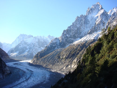
Mer de Glace (Sea of Ice) Glacier, Mont Blanc massif, France
The Mer de Glace (Sea of Ice) glacier can be reached through the Montenvers train. This glacier is located on the northern slopes of the Mont Blanc massif and is deemed the longest glacier in France at 7 Km long and 200m deep. Its speed is about 90 meters per year. This was easily visible from Chamonix at one point of time but it has been receding and is now not visible.
The Montenvers Railway commenced in 1908. It makes its way along the Aiguilles de Chamonix. The Montenvers station has restaurant, café and restrooms. One can see the Mer de Glace, Les Drus (Aiguille du dru), the Aiguille du Grepon and the Les Grands Jorasses from here. A cable car leads right to the ice grotto (ice cave).
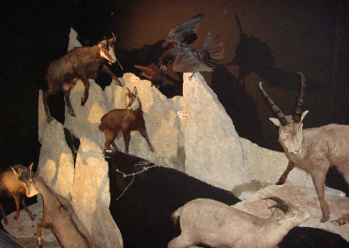
But this is a tourist spot and the glacier attracts a large number of visitors. It has viewing platforms and also very small incongruous museum on its indigenous animals and birds and another on crystals.
Mer De Glace Glacier France
Located in the French Alps, Mer de Glace is the largest glacier in France. Its surface area is approximately 40 kilometers. It is located on the northern slopes of the Mont Blanc massif. Its length is approximately 7 kilometers. The depth of the glacier is approximately 200 meters.
Mer de Glace is one of the world’s most visited natural sites. There are many facilities and activities available for tourists to enjoy. Some include a museum on crystals and indigenous animals, a cafe and restaurant, and a small museum about the glacier. A cable car to Grotte de Glace is also available. The train station has a restaurant and restrooms. There are hiking and ski trails to get to the glacier. Visitors can also hike to Plan de l’Aiguille or Grand Balcon Nord. This route is about a two-hour hike from Chamonix.
During the past three decades, the Mer de Glace has retreated about two kilometers. This is a significant loss considering the glacier once reached as far as Chamonix. The lower end of the glacier has been shrinking at an average rate of 4-5 meters per year. It is expected that the snout will recede further in the next two decades. The worst-case scenario would see the glacier retreat by 1.4 kilometers. The Compagnie du Mont Blanc SA is planning to relocate the access to Mer de Glace 700 meters along the glacier line.
The surface of the Mer de Glace is rough and features large hunks of ice and deep crevasses. The glacier is also extremely dangerous. It is not recommended for climbers or skiers to visit the glacier unless they have a local mountain guide. The area is also dangerous to visit during the summer months, as it is very difficult to get there.
There are two flux boundary conditions that drive the evolution of the Mer de Glace. One boundary condition imposes ice flux from the upper part of the glacier and the other imposes ice flux from future estimates. The ice flux from the upper part of the Mer de Glace was determined by measurements from past observations and ice flow velocities. The ice flux from the lower part of the Mer de Glace was determined using the Elmer/Ice ice flow model. It is used to simulate the evolution of Mer de Glace until 2050.
The ice flow description of the Mer de Glace enables us to quantify the relative contribution of different processes to the glacier’s retreat. One third of the increase in thinning rates was caused by surface ablation. The other two thirds was caused by reduced ice fluxes at the Tacul gate. In hindcast simulations of the period 1995-2015, the rate of retreat was 35 meters per year. The rate of retreat was significantly lower in forecast simulations.
The surface of Mer de Glace is estimated to shrink by about 1.2-1.4 kilometers by 2040. This would put the Mer de Glace at the same level as the Chamonix Valley, which is located approximately 600 meters above the snout.
Below: The Mer de Glace or “Sea of Ice”. The shrinking of the glacier is more than evident.
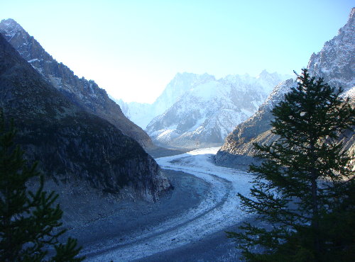
Around the Mer de Glace glacier. The Les Grands Jorasses can be seen in the farther end.
The museum with stuffed animals –
Skiing in Les Houches (Mont Blanc region/French Alps)- Tourist/Visitor info
Les Houches provides a wide range and variety of slopes – from beginners to professionals and high to low slopes through forests. It has 2 black slopes (one is the Verte Piste), 13 red, 7 blue, 4 green slopes and 1 for children. Much of them are maintained by artificial snow. The Verte Piste is famous for meets for Alpine World Cup downhill and slalom events. It is a black run of 3343 meters. Declivity is 870m. The Verte hosts the Kandahar downhill and slalom events on the World cup circuit. Les Houches also hosts the Telemark World Cup.
Guides and Adventure School in Les Houches-
The ESF or French Ski School represents the company guides for the skiing, trekking, ski touring et al. Information about the Ski guides can be obtained from +33 (0) 4 50 54 48 79 or +33 (0) 4 50 54 50 76.
The French Ski School provides lessons in French, English, German, Italian, Spanish and Russian. They can be contacted at –
• Main office at Les Chavants – +33(0)4 50 54 48 79
• Office opposite the tourist office – +33(0)4 50 54 42 96
• Office opposite Bellevue cable car- +33(0)4 50 54 61 79
Adventure and ski sport school (Evolution2) information and reservation available at +33(0)4 50 54 41 02
Les Houches tourist office – +33 (0) 4 50 55 50 62.
Ski Passes can be obtained from the following –
1) The Prarion bubble lift – +33 (0)4 50 54 42 65
2) Bellevue cable car – +33 (0)4 50 54 40 32
3) Maisonneuve chairlift – +33(0)4 50 55 51 54
Insurance is required. It can be obtained from the Tourist Office.
Other important numbers –
Pharmacist at Les Houches – +33(0)4 50 54 40 24 (Mon-Sat: 9:15am-12:30pm & 2:30pm – 7:30pm)
Police (Les Houches)– +33(0)4 50 53 00 55 or 17
International emergency number from a mobile phone – 112
Mountain Rescue (Les Houches, France) – +33(0)4 50 53 16 89